


Drone Sky Defender — Professional Drone Detection & Airspace Security Solutions
DETECT, TRACK, IDENTIFY, and DEFEAT unauthorized drones before they become a threat — trusted by government, security teams, and facility operators.
Predictive Drone Threat
Intelligence Detection Systems
Our AI models don't just detect drones—they forecast their launch point, path, and intent. Unlike traditional systems, we think ahead.
-
Launch Origin Estimation
-
Flight Behavior Fingerprinting
-
Intent & Payload Prediction
-
Toxic Corridor Modeling
Using machine learning, behavioral databases, and real-time RF and telemetry inputs, we identify threat patterns unseen by human observers or standard RF systems.
The list below is some of our INTELLIGENT DETECTION SYSTEMS that can be integrated into your overall detection package.
STEP 1
Detect
Detect drones with precision-engineered RF technology.
STEP 2
TRACK
Track their movements in real time for enhanced situational awareness.
STEP 3
IDENTIFY
Identify drone make, model, and operator location for rapid response.
STEP 4
DEFEAT
Defeat threats safely and effectively, mitigating risks without disruption.

Prisons & Correctional

Professional Drone Detection & Airspace Security

Real-Time Detection & Alerts

Drone Detection Products

Airports

Law
Enforcement

Critical Infrastructure
Corporate,
Goverment &
Educational
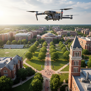
Campuses

Construction
Sites

Stadiums &
Public Events

Mobile Security
Data Centers
Protect restricted and sensitive airspace with real-time drone detection, identification, and threat awareness — powered by advanced RF sensing and predictive analytics.
Built for prisons, corrections, law enforcement, airports, critical infrastructure, and government operations, just to name a few. If you have a use case reach out to us for a custom quote.

What Drone Sky Defender Does.
Drone Sky Defender provides cost-effective drone detection systems that identify, track, and log unauthorized drone activity before it becomes a security incident.
Our technology enables security teams to:
-
Detect drones transmitting Remote ID and other RF signals
-
Identify drone manufacturer and model
-
Locate drone and pilot positions (when available)
-
Monitor airspace in real time through a secure cloud dashboard
-
Maintain historical flight logs for investigations and reporting
We focus on early detection and actionable intelligence, not expensive or invasive countermeasures.
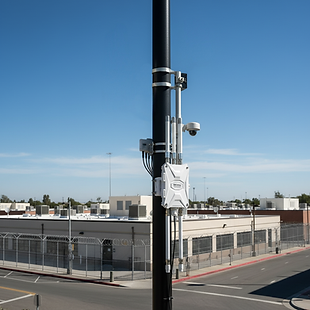
UAS Sentry System Products
The UAS Sentry system is a versatile, lightweight, and portable solution that can be easily set up and installed for both mobile and stationary applications. With its highly configurable design, the UAS Sentry system can quickly adapt to meet the demands of any project, making it an ideal solution for a wide range of applications. Whether you need to monitor a remote location or protect a sensitive area, the UAS Sentry system is the perfect tool for the job. With its ease of use and flexibility, you can get up and running in no time and start seeing results right away.
Drone Identification
When a drone takes off, it's required to broadcast a Remote ID identifier that includes its geographic location (latitude, longitude, height, heading, speed) as well as the pilot's location (latitude, longitude).
UAS Sentry Can Detect Remote ID Identifiers
UAS Sentry can detect drone Remote ID identifiers and display an alert if a drone enters the area. The data is sent directly to a connected phone or cloud account for live map updates and group distribution.
Real-time Tracking
The cloud service sends out alerts to specified devices when a drone enters an exclusion area, and the data allows for real-time tracking on a maps screen. The data is also available for later tracking and analysis.
Connected Devices
UAS Sentry connects to a phone or cloud account for easy access to data and real-time updates, providing a comprehensive view of drone activity in the designated area.
Detectable Drones
This not a complete list, drones are added on a constant basis.
Features
REMOTE ID DETECTION
UAS Sentry is able to detect and identify drones in the airspace through the use of Remote ID technology.
-
* Drones must be Compliant with Remote ID by September 16 2023
-
22.5 Billion Drone Sales 2020
-
87.5 Billion Estimated by 2026
-
269k FAA Certified Pilots 2022
-
220k Recreational Pilots 2022
-
856k Registered Drones 2022
* Drones which weigh over 250 grams OR used for commercial purposes must be RID compliant by 9/16/2023. Drones flying at an approved RC field or FRIA (FAA-Recognized Identification Areas) 'may' be exempt. As of 7/7/2023 the FAA has not approved any RC fields or FRIAs.
MOBILE DEPLOYMENT
UAS Sentry can be mounted on a mobile platform, such as a vehicle, to provide a moving security area.
DRONE OPERATOR LOCATION
UAS Sentry is able to identify the location of drone operator through Remote ID data, allowing for appropriate action to be taken.
ALERT NOTIFICATIONS
UAS Sentry is able to send alert notifications to designated personnel or authorities when a drone is detected, providing early warning of potential threats.
REAL-TIME TRACKING
Once a drone is detected, UAS Sentry is able to provide real-time tracking of its location, altitude, heading, and speed.
CLOUD-BASED SERVICE
The data from UAS Sentry is transmitted to a cloud-based service for storage and analysis, providing valuable information for future security planning.
MULTIPLE DRONE DETECTION
UAS Sentry is able to detect and track multiple drones in the same airspace simultaneously.
MULTI-SENTRY NETWORK
Multiple UAS Sentry’s can be used together to increase site, and route security.